Applied Science
| Title | Preparatory studies towards Scientific deep drilling programme in Koyna-Warna region |
|---|---|
| Participants | N. Purnachandra Rao, Sukanta Roy, Mrinal Sen and Harsh Gupta |
| Sponsoring Agency | Ministry of Earth Sciences |
Work Description:
The Koyna region located close to the west coast of India is the most outstanding example of Reservoir Triggered Seismicity (RTS), where triggered earthquakes have been occurring in a restricted area of 20x30 sq km since the impoundment of Shivajisagar Lake in 1962. The continued seismicity ever since provides a unique opportunity to directly measure the physical and mechanical properties of rocks, pore fluid pressure, hydrology, temperature and other parameters of an active intra-plate seismic zone in the “near-field” of earthquakes – before, during and after their occurrence, at shallow depths accessible by drilling. In view of this, a scientific deep drilling experiment for earthquake studies is planned in the Koyna-Warna region where a ~ 7km deep borehole observatory is planned to be set up for direct and continuous monitoring leading to a better understanding of the mechanics of faulting and physics of the reservoir triggered earthquakes, which will contribute appreciably to earthquake hazard assessment in future.
Towards this goal, a suite of geophysical investigations at regional and local scales, like broadband Seismology, Broadband Magneto-Tellurics (MT), Deep Resistivity Sounding (DRS), Controlled Source Audio-frequency Magnetotellurics (CSAMT), land-based gravity-magnetics, airborne gravity-gradiometry and LiDAR surveys are being carried out to precisely delineate the sub-surface structure around the seismic zone, most prospective for scientific deep drilling and fault zone investigations (figure 1.1). This is supplemented by about 9 – 10 exploratory boreholes ~1.5 km deep, surrounding the seismic zone. Apart from a suite of borehole investigations including geophysical logging and hydrogeology, borehole Seismology is being undertaken in these boreholes for precise delineation of hypocentral trends and fault plane geometry for taking up the deep drilling experiment.
The present study based on a multi-disciplinary approach is expected to provide a plethora of valuable geological, geophysical and geotechnical data from the boreholes. One of the major outcomes would be the accurate hypocentral locations of the order of a few tens of meters through inversion of travel time data recorded on borehole seismometers. This would be critical for delineating the fault zone in the study region. Further, modeling of borehole seismic waveform data including the fault guided waves will provide an additional, independent constraint on delineation of fault zone for planning of the deep borehole drilling in future. The structural changes with depth obtained from drilling, the various ongoing geophysical studies including MT, DRS and CSAMT, characteristics of water bearing formations identified at various depths through hydrogeological investigations and the surface geological and geomorphological results from airborne LiDAR would form the basis for further planning of the deep drilling experiment and modeling of the reservoir trigger mechanism in future.
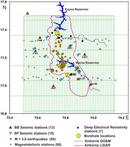
Fig.1.1: Ongoing studies in the Koyna-Warna region