Applied Science
| Title | GROUNDWATER EXPLORATION FOR SOURCE CREATION AND RECHARGE SITES LOCATION |
|---|---|
| Participants | S.N. Rai, S. Thiyagarajan, Dewashish Kumar,. G.B.K. Shankar, M. Sattesh Kumar and. R. Rangarajan |
| Sponsoring Agency | CSIR-NGRI |
Work Description:
(i) Electrical Resistivity Tomography for groundwater exploration in basaltic terrain of Tawarja basin, Latur district, Maharashtra
Electrical Resistivity Tomography has been carried out at 15 locations in the western part of the Tawarja river basin (Latitudes: 18o 12’ 16” – 18 o 24’ 15” and Longitudes: 76o 15’ 22” – 76 o 41’ 35”), Latur district which is a part of draught prone area in Marathwada region of Maharashtra State. The basin is occupied by Deccan traps basalt formation and receives an average annual rainfall of 880 mm. This region is facing acute shortage of water supply to meet the requirements of irrigation and drinking water. The groundwater in the unconfined aquifers has been completely exploited. Therefore, deeper sources of groundwater within the traps need to be delineated to meet the water supply demand. Groundwater potential zones within the intertrappean sedimentary formations between two successive lava flows and in fracture zones have been delineated at several locations in the investigated area. Interpreted result about the occurrence of groundwater potential zone has been verified by drilling a bore well at a site falling under administrative limit of Karkota village.
(S.N. Rai, S. Thiagarajan, G.B.K. Shankar and M. Sateesh Kumar)
(ii) Exploring groundwater at CSIR-NGRI campus
CSIR-National Geophysical Research Institute is geographically located between 78o 32’49.2” to 78o 33’25.2” E longitudes and 17o 24’28.8” to 17o 25’8.4” N latitudes in the capital city of Hyderabad. Location map of the study area is shown in
Fig. 3.1. Electrical Resistivity Tomography along eight profiles is carried out within the campus to delineate groundwater potential zones characterized by resistivity value < 45 Ohm m and that of massive granite is > 70 Ohm m resistivity values. Inverse resistivity model of ERT at E7 site and colored index of the resistivity values are given below the model. A new bore well drilled at E7 yielded 1.5 liters per second. Groundwater flow from the bore well is also shown in Fig. 3.3.
(S.N. Rai, S. Thiagarajan and Dewashish Kumar)
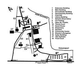
Fig.3.1:
Location of ERT sites (E1 to E7)in NGRI campus
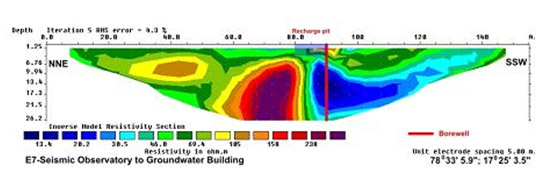
Fig.3.2:
Resistivity imaging at a site near Groundwater building
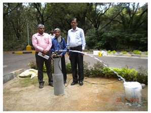
Fig.3.3:
Wavelet power spectra for the periods 5 to 2 years for all the data sets used in the study
(iii) Groundwater exploration in Koilagudem village revenue area, Nalgonda district, A.P.
Koilagudem village in Choutuppal Mandal of Nalgonda district was referred by the Honorable Governor of Andhra Pradesh to take up scientific studies to solve the drinking water problem of this village. Vertical Electrical sounding (VES) at 3 sites in the area around the village and ERT imaging were taken at 2 sites in a Tangadapalle cheruvu area adjacent to this village for source finding
A borehole site was identified in the village revenue area and drilling was recommended to a depth of 100 m for supporting the present water supply scheme. A large diameter dug well (6-8 m dia) to a depth of 15 m at a selected site in the Tangadapalle cheruvu was also recommended. The dug well source may be adequate to meet the requirements of Koilagudem and other villages.