Basic Science
| Title | Meteorite impact cratering processes on Earth and other planets |
|---|---|
| Participants | P. Senthil Kumar, R. Menon, K, J. Prasanna Lakshmi, N. Krishna, A. S. Kumar, V. Keerthi |
| Sponsoring Agency | CSIR-NGRI |
Work Description:
[1] Impact fragmentation of basalt at Lonar crater
Impact fragmentation is a fundamental geologic process that affected all planetary bodies. Basalt is common on the surfaces of terrestrial planets and is extensively damaged by meteorite bombardment. Lonar crater is a unique basaltic impact structure on Earth that preserves the fragmental ejecta around the 1.8 km diameter crater (Figure 45.1). To understand the process of impact fragmentation in the basaltic target, we characterized the ejecta fragments and the crater interior of Lonar crater and compared with the data from other planetary bodies. Upper surface of the Lonar ejecta is largely made up of sand-pebble size particles, which are underlain by cobble-size angular fragments. Decimetre to meter size angular boulders are abundant near the crater rim, while they are scattered elsewhere in the ejecta. Based on several hundreds of size measurements in the field, cumulative size-frequency distribution of pebble to cobble size fragments define an average power-index (b value) of -2.5, while it is higher (-3.4) in the boulder size ejecta. These results are comparable to the cumulative size-frequency distribution of the near-earth asteroid Itokawa. On the other hand, the Lonar fragments have lower power indices than the impact and volcanoclastic fragments on the Moon (-4.5 and -4.2, respectively). The differences in the power-indices within the Lonar ejecta and between planetary objects should indicate the complexity in the impact fragmentation processes. The cumulative mass-frequency distribution of the Lonar ejecta confirms the complexity in terms of single or multiple fragmentation events. Our field observations in the proximal ejecta of Lonar clearly point to multiple collisions between the basaltic fragments during the ejecta emplacement, which reflect in the power index values. Shape of the Lonar fragments were also defined based on 1300 measurements of principal axes. They are mostly compact, platy, bladed and elongated shapes or a complex combination of these forms. Interestingly, the shapes of Lonar fragments are similar to those of experimental impact fragments and Itokawa, but are different from the lunar fragments. Several hundreds of edge angles were measured on the Lonar fragments, they provide an average value of 100 degrees, which are again similar to those measured on asteroid surfaces. To understand the provenance of cobble-boulder size ejecta, we made more than 2400 fracture spacing measurements throughout the upper crater wall. The cumulative fracture-spacing frequency distribution of the upper crater wall (power index = -3.3) is dramatically similar to the gravel size ejecta fragments (power index = -3.4) (Figure 45.2). This confirms that most of the decimeter to meter size fragments were originated from the upper interior wall, where a thick massive basaltic lava flow is exposed. In addition, we carried out laboratory reflectance spectroscopic measurements of both fine ejecta fractions and the bedrock samples from the crater interior in the wavelength range of 400-2500 nm. The fine ejecta is characterized by the spectral absorption features indicative of abundant Fe-Mg rich phyllosilicates (clays), which are largely found as layers of redbole in the upper to middle crater wall. The spectral similarity between the fine ejecta and the redbole layers clearly show that the cratering event excavated the phyllosilicate layers beneath the massive basaltic flow in the upper wall. A large number of impact craters on the Mars contain phyllosilicate-rich ejecta that were originated from the subsurface phyllosilicate-rich layers. We obtained shear wave velocity images of the Lonar ejecta using multi-channel analysis of surface waves, which revealed the spatial variation of ejecta thickness and zones of concentration of cobble-boulder size fragments within the ejecta. Density, P and S wave velocity and uni-axial compressive strength of the ejecta fragments were also measured. This petrophysical data are useful in the numerical modelling of the impact event at Lonar.
[2] Origin of boulders on the Moon by impact processes:
Boulders are ubiquitous on the surface of Moon, as they were produced by impact cratering processes. It is well known that these boulders range in size from a few meters to several tens of meters. The size of boulders decreases from the crater rim to large distances, as a function of an increase in the ejection velocities. The boulders are also responsible for the formation of secondary impact craters on the Moon. Here, we investigate the nature of boulders in and around an impact crater (400 m diameter) in Oceanus Procellarum. It is a fresh crater with well developed ejecta and rays. Using Lunar Reconnaissance Orbiter Narrow Angle Camera image, we mapped the boulders around the crater using ArcGIS mapping tool (Figure 45.3). About 2227 boulders were mapped. Size of these boulders varies from 1.25 m to 13 m. A maximum range of the boulders from the crater center is ~870 m. Axial ratio of the boulders is found to vary from 0.3 to 0.9 with a majority around 0.7. The cumulative size frequency distribution of these boulders define a power index -4.54 in the diameter range of 3-11 m. The power index is very high compared to those in the ejecta blanket of Lonar crater, which is a terrestrial impact crater. We suggest that the steep power-law slope of the lunar boulders is due to multiple fragmentation in the lunar regolith. Our interpretation is consistent with our geological observations from the crater interior that exposes a thick fragmental layer. The similarity between the boulders in the fragmental layer and those on the ejecta further supports this hypothesis. The presence of a central mound on the crater floor and the V-shaped ridges emanating from the eastern crater rim indicate that it is a oblique secondary impact crater of Copernicus.
[3] Geological mapping of the Lada Terra quadrangle(V-56), Venus
Geological mapping of Venus has been undertaken at a wide variety of scales and by a large number of individuals, including broad terrain maps derived from Earth-based radar images, classifications and geo¬logic mapping based on Pioneer-Venus topography and imaging, comprehensive geological mapping based on the northern area covered by Venera-15/16 radar and altimetry data, specific thematic areas using all available data sets, generalized global terrain maps 2 compiled using Magellan data, and specific areas (quadrangles) mapped at specific scales. An example of the latter is the currently ongoing NASA program administered by the U.S. Geological Survey that involves many individual geologists and their co-workers. These NASA/USGS mapping efforts have resulted in publica¬tion of more than half of 62 1:5,000,000-scale quadrangles that cover about 45 percent of the surface of Venus. These maps provide valuable documentation of the local to regional geologi¬cal settings and processes. In this regard, a geological map of Lada Terra quadrangle (V–56), a portion of the southern hemisphere of Venus that extends from lat 50° S to 70° S and from long 0° E to 60° E, has been prepared and is currently in production (SIM 3249) in the USGS. The geological map of V–56 quadrangle reveals evidence for tectonic, volcanic, and impact processes in Lada Terra in the form of tesserae, regional extensional belts, coronae, and volcanic plains. In addition, the map also shows relative age relations such as overlapping or cross-cutting relations between the mapped geologic units. The geology observed within this quadrangle addresses (1) how coronae evolved in association with regional extensional belts and (2) how tesserae, regional plains, and impact craters, which are also significant geological units observed in Lada Terra quadrangle, were formed.
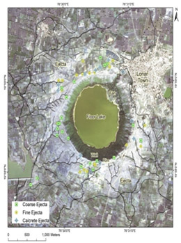
Fig.45.1:
QuickBird image showing Lonar crater and distribution of sample locations.
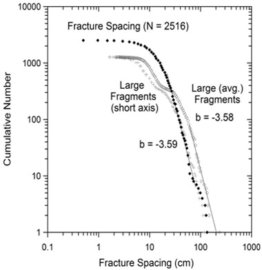
Fig. 45.2 :
A comparison of fragment size distribution of Lonar crater ejecta with the fracture spacing distribution in the upper crater wall.
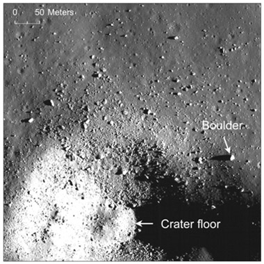
Fig. 45.3 :
A 400 m diameter lunar crater showing the distribution of boulders in and around the crater.